
SDI Services
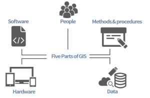
One of Upande’s core services revolves around so called Spatial Data Infrastructure (SDI). An SDI typically consists of 5 parts as outlined in the diagram below, namely: People, Methods & Procedures, Hardware, Software and Data.
Why SDI?
- Reduces duplication of efforts.
- Lower costs related to geographic information while making geographic data more accessible.
- Increases benefits of using available spatial data.
- Establishes key partnerships between the sectors that are utilizing it.
- Allows spatial information to be integrated from a variety of disciplines for a variety of uses.
Examples of SDI
GeoNode is a web-based application and platform for developing geospatial information systems (GIS) and for deploying spatial data infrastructures (SDI). Upande has almost a decade of experience setting up custom GeoNode based SDI systems:
-
- Nairobi Metropolitan Government
- Biodiversity Atlas of Kenya
- Washmis GIS
- Virtual Kenya
- Snieau
- MaMaSe
Expertise
Despite rapid advances in automation and machine learning, human skillset and actions will remain core of any GIS system in the next few years.
Knowledge and experience in your GIS staff are required at all levels, from enumerators to analysts to database managers to project managers.
GIS exposure and expertise starts at the University level in many cases. Having said that, technology is advancing at such a rapid rate that lecturers and professors ideally have to revisit their curriculum every year. Needless to say there is always a lag in what they are able to offer and on what the latest developments are.
Upande prides itself in working with cutting edge technology in its national and international projects. As a result, we are able to offer consultancy or training in some of the latest technologies available.